Autonomous Mapping Evaluation and Evasion — AMEE (Autonomous Mapping Exploration and Evasion) is a fictional military robot from the 2000 film Red Planet.The film takes place on the barren surface of Mars, where the remaining crew members must battle against the deadly elements, the lack… … Wikipedia
APG-66 — The AN/APG 66 radar is a solid state medium range (up to 150 km) Pulse doppler radar designed by Westinghouse (now Northrop Grumman) for use in the F 16 Fighting Falcon and in the U.S. Customs and Border Protection s C 550 Cessna Citation and… … Wikipedia
AN/APG-66 — Tipo Radar mecánico País de origen Estados Unidos Historia de … Wikipedia Español
List of radars — This is a list of radars. A radar is an electronic system used to detect, range (determine the distance of), and map various types of targets. United States Military Naval Early S band RADAR DesignationsMacintyre, Donald, CAPT RN Shipborne Radar… … Wikipedia
F-16 Fighting Falcon — infobox Aircraft name= F 16 Fighting Falcon caption=A USAF F 16 over Iraq after refueling, 2008 type= Multirole fighter national origin = United States manufacturer= General Dynamics Lockheed Martin first flight= 2 February avyear|1974… … Wikipedia
Organisation européenne pour l'équipement de l'aviation civile — L Organisation européenne pour l équipement de l aviation civile (EUROCAE, acronyme de EURopean Organisation for Civil Aviation Equipment) est un organisme européen qui fédère les acteurs du domaine de l aviation civile afin d établir des règles… … Wikipédia en Français
Geophysical MASINT — is a branch of Measurement and Signature Intelligence (MASINT) that involves phenomena transmitted through the earth (ground, water, atmosphere) and manmade structures including emitted or reflected sounds, pressure waves, vibrations, and… … Wikipedia
Defence Research and Development Organisation — Sanskrit: बलस्य मूलं विज्ञानम् Strength s Origin is in Science [1] Agency overvi … Wikipedia
AN/APG-67 — Infobox Radar name = AN/APG 67 caption = country = United States introdate = 1983 number = type = Solid state active electronically scanned array (AESA) frequency = X band range = 148 Km altitude = diameter = azimuth = elevation = precision =… … Wikipedia
RDY (Radar Doppler Multitarget) — RDY= Radar Doppler Multitarget ( RDY in its French acronym) is a multimode fire control radar that was originally designed for the Mirage 2000 5 fighter by Thales.DescriptionCentral to the upgraded multirole capability of the Dash 5 is the RDY… … Wikipedia
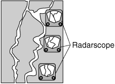 Actual ground features and as seen on the radarscope.